Riverfront History
A Riverbank History of the Midlands
The Congaree, Broad and Saluda Rivers
As is often the case, Columbia’s history is tied inextricably to its landscape, and more specifically, its rivers. Serving as the highway of the day, South Carolina’s rivers provided ready access to an inland wilderness. Lowcountry Rivers led inland to the fall line, the area where the piedmont meets the coastal plain; an area that is characterized by the rapids and shoals of the Congaree, Broad and Saluda. It is a landscape of rivers, flood plain swamps and hardwood bluffs. These rivers tell a history of our state and our capital, Columbia.
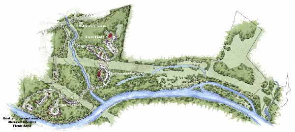
Above (1): The plan for Saluda Shoals Park.
Fort Congaree was first built in the early 1700’s near a Native American trading post along Congaree creek. It was a crossroads of the Catawba and Cherokee Nations and the staging point for backcountry development in the state. Above the Congaree was no man’s land, although both tribes traveled the riverbanks to fish and hunt. Eswa Huppiday meaning “Line River” divided the territory with the Catawba claiming the land to the north and the Cherokee hunting the lands to the south. This was the Broad River.
As early settlers began to move inland from the coast seeking fertile farmlands, native populations were displaced and populations declined as a result of smallpox epidemics brought to the continent by European settlers. Eventually the expansion reached the Congaree River Valley. Affluent planters introduced the plantation system and took advantage of the existing native infrastructure, converting trading paths to roads and ferries crossings across the swamp as a means of transporting goods back to Charleston for market.
The village of Granby was established on the Congaree in what is now Cayce in 1753. It was made the county seat of government, home to a courthouse, stores, boat landing and numerous houses. A major ferry crossing along the Congaree River, know as Friday's ferry, served the area.
The Saluda River Valley was settled by German-speaking immigrants in the 1700’s. The Dutch Fork name is likely a mispronunciation of Deutsch, reflecting this heritage.
In 1786 the South Carolina General Assembly directed that the seat of government be moved from Charleston to Columbia, and with that the lower lying Granby was slowly forgotten. Columbia is set on a plateau 350 feet above mean sea level overlooking the Congaree at the confluence of the Broad and Saluda Rivers. In 1791, Wade Hampton built a bridge crossing the river connecting Granby to Columbia. The bridge would be washed out and rebuilt several times before the end of the century. Bridges built by John Compty just upstream on the Broad River met a similar fate.
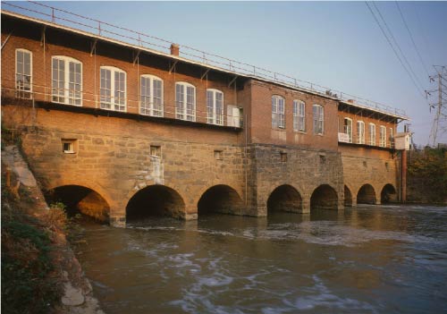
Above (2): The Columbia Canal.
Rivers would serve as the most important means of transportation in the state for the next 50 years. As river traffic increased, and Columbia began to grow, it became necessary to build a canal. It would be completed by 1824. The canal was excavated below the falls on the Broad River, just north of the city. It had an eight foot-wide towpath on each side. The state sponsored Columbia Canal was a notable example of engineering expertise in the nineteenth century. Robert Mills, a federal architect, was instrumental in its development. It would play a significant role in Columbia’s commercial and industrial growth.
The Congaree River was navigable for steamboats from Columbia to the Santee River. The waterway of more than 175 miles in length eventually drained into the Atlantic Ocean. Steamboats, tugs and canal boats regularly made the trip from Columbia to Charleston, via the Santee Canal, with more than 30,000 bales of cotton annually, and with full return freights. In 1822, the Carolina made the trip upriver in 4 ½ days.
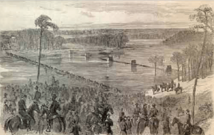
Above (4): Historical depiction of Sherman crossing the Broad River in pursuit of Confedearate troops. Both the Congaree and Broad River bridges were burned to slow the Northern advance.
In 1827, a bridge was constructed across the Congaree at the foot of the burgeoning industrial and commercial Gervais Street. A new era of industry had arrived in the city. The Broad River Bridge was built two years later in 1829 and a 1500 ft dam constructed to channel water into the Columbia Canal along the Broad River near its confluence with the Saluda.
In 1830, the Saluda Factory was built as one of the first textile factories in the state. Ten years later, the State would drop its subsidy of the canal and by 1842 the railroads would arrive. Canal traffic decreased and its subsequent use was transferred to local commerce and as a hydraulic power source for industry. By 1846, railroad services were extending into the Upstate—Greenville, Spartanburg, Anderson area.
In 1865, on the 17th of February, General W.T. Sherman would enter the city. It would nearly be destroyed by fire. After the end of the Civil War, Columbia would rebuild. The canal would be enlarged and would run along the Congaree for about three miles, providing electricity for emerging textile mills.
By 1894, as a result of mill growth, mill villages began to emerge along the riverbanks in the Midlands. The planned community of Brookland housed mill workers in what is now West Columbia. Ferry boats were used to transport workers across the river to the mill, but with time, the need for a bridge became apparent. The Guinard family built a wooden bridge providing access to the mill and uniting the riverbank communities, as demand for wanting to visit Columbia in- creased.
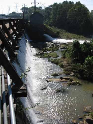
Above (5): The falls at the Columbia Canal.
Six textile mills were built in Columbia between 1890 and 1905. Cotton production in the state was among the largest in the country. Olympia Mills was one of the largest cotton mills in the world under one roof. Columbia experienced remarkable growth during this time. The Congaree River played a significant role in providing power.
Columbia lies on a large out- crop of granite and in the 1850’s mining operations began on the river behind Granby Mill Village. The statehouse would be built of this material. To this day, material from the quarry is used in highway building. Shale and clay deposits provide raw material for brick and shale plants. The Guinard Brick Works produced bricks for many of the buildings in Columbia from around 1900 to the mid-twentienth century.
In the early 1900’s, Irwin Park provided a public space for Columbia’s growing population. It was situated along the canal with lined trees and landscaping to screen the large concrete walls of the penitentiary. There was also a zoo in the area where camels, deer, and exotic birds could be viewed.
The Gervais Street Bridge construction began in 1926 and was completed in 1928. It is one of four spandrel arched bridges of reinforced concrete in the state. From 1928-1953, the Gervais Street Bridge would be the only means of crossing the Congaree. Designed by Joseph W. Barnwell, it is the earliest and most decorative of the three bridges that now cross the river.
In 1927, plans for the largest earthen dam in the world had been set in place, and by 1933, the landscape would change dramatically. Lake Murray inundated some 78 square miles of land as one of the largest man-made lakes in the world.
The Congaree, Broad, and Saluda Rivers provide miles of riverfront for South Carolina’s capitol city and played a significant role in Columbia’s landscape history. The story of our history is tied to the land, and as with many places, a river runs through it.
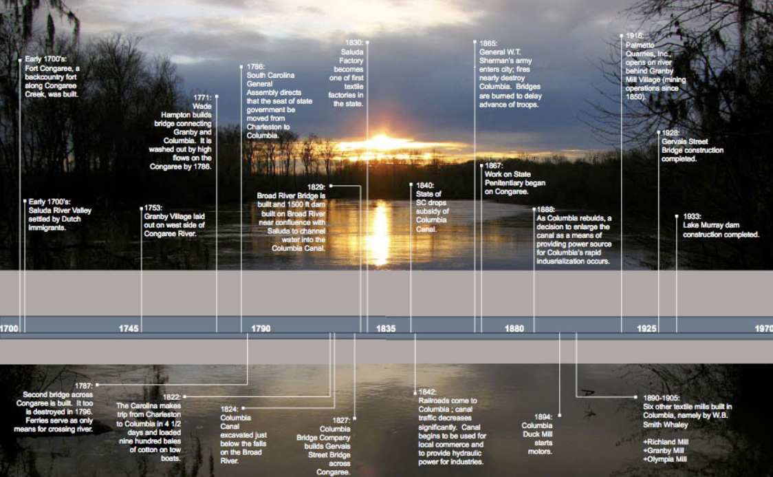
Timeline
Below is a timeline of the Riverfront from the early 1700 - c.1930
Sources
Deas-Moore, Vennie, Columbia’s Riverbank: A history of the waterways. (:ill.) Charleston, SC: History Press, 2008.
Edgar, Walter B., Woolley, Deborah K. Columbia, portrait of a city. Norfolk, Va.: Donning Co., 1986.
Kline, W. S. Columbia, the Capitol City of South Carolina: its history, resources, development and enterprises. 1904(?).
Montgomery, Edgar A. Columbia, South Carolina: history of a city. Woodland Hills, CA: Windsor Pub. Inc., 1979.
Sennema, David C., and Martha D. Sennema. Columbia, South Carolina: a Postcard History. Dover, NH: Arcadia Pub., 1997. Print.